What is an orthophoto? How it differs from an aerial photo
What is an orthophoto, how perspective is corrected, what an orthomosaic is and why a drone orthophoto can be measured while an aerial photo cannot.
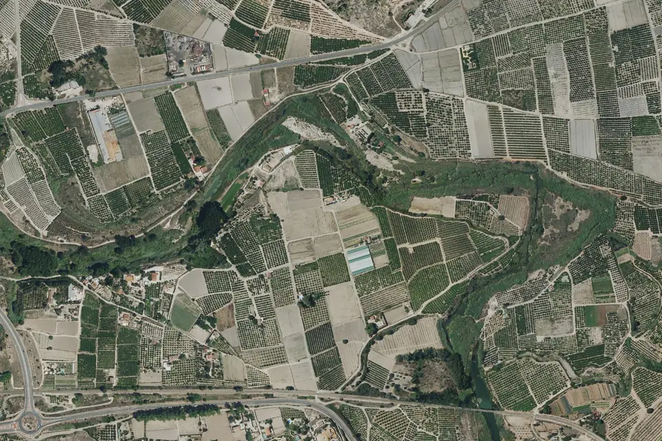
An orthophoto is an aerial image that has been geometrically corrected so that it has the uniform scale of a map. Unlike an ordinary aerial photograph, an orthophoto can be used to measure distances, areas and coordinates. This article explains what an orthophoto is, how it is produced, what an orthomosaic is and what a drone orthophoto offers compared with the public orthophotos of the PNOA (Spain’s National Aerial Orthophoto Programme).
What is an orthophoto? The short definition
The name comes from ortho, straight, and photo. An orthophoto is a photograph projected orthogonally onto the ground, as if every point had been photographed from directly above it.
In an ordinary photo, the camera is at a single point and everything that is not directly below it is seen in perspective. In an orthophoto, that perspective has been removed. The result combines the best of both worlds: the visual detail of a photograph and the geometry of a map.
Technically, an orthophoto is a georeferenced raster: each pixel has known coordinates in a coordinate reference system (in Spain, ETRS89 UTM) and a real size on the ground, the GSD.
Orthophoto vs aerial photo: why an aerial photo cannot be measured
A conventional aerial photograph, even a vertical one, has two distortions that make it useless as a map.
Central perspective
The camera lens concentrates all the rays at one point. Objects far from the centre of the image lean outwards. In a photo of a town taken from the air, you see the façades of the buildings at the edges, never those in the centre. That lean increases with the distance from the centre and with the height of the object.
Relief displacement
The terrain is not flat. A point on a hill is closer to the camera than one in a valley, and the scale of the photo changes from one place to another. Two plots of the same size can take up different areas in the image simply because of their elevation.
Add to this the tilt of the camera at the moment of capture and the lens distortion. With everything combined, measuring on an uncorrected aerial photo gives errors of metres.
A georeferenced photo is not an orthophoto
This is a common confusion. A georeferenced photograph is an image that stores in its metadata the position and orientation of the camera when it was taken. It tells you where it was taken and it feeds the photogrammetric processing, but it still has uncorrected perspective and relief. The orthophoto is the end product of that processing, not the starting photo.
How a drone orthophoto is produced
The orthophoto is the result of the photogrammetric process. The steps are the same with an aircraft or a drone; what changes is the altitude and, therefore, the detail.
- Photogrammetric flight: the drone covers the area in parallel flight lines, with a metric RGB camera that takes a photo every few metres. The images overlap by 70-80 % along the flight line and 60-70 % between flight lines. Each image carries the GNSS RTK position of the drone.
- Ground control points: before the flight, targets are measured in the field with GNSS RTK or a total station. Some are used to adjust the image block and others, kept independent, to check the final accuracy.
- Image orientation: the software identifies common points between photos and calculates the exact position and orientation of each one (aerial triangulation).
- Dense point cloud and elevation models: from the oriented images, the height of each pixel is calculated and the digital surface model (DSM) is built; filtering it gives the digital terrain model (DTM).
- Orthorectification: each image is projected onto one of those models, the DTM or the DSM, as explained below, correcting perspective and relief pixel by pixel.
- Mosaicking: the rectified images are joined, seamlines are chosen in areas without tall objects, and colour and brightness are balanced.
The end product is the orthomosaic: a single continuous image of the whole area. In practice, orthophoto and orthomosaic are used as synonyms; strictly speaking, the orthomosaic is the set of many orthophotos joined together.
Standard orthophoto and true orthophoto
There is a technical nuance with practical consequences. If rectification is done on a terrain model (DTM), the ground is perfect but the buildings still lean, because the model does not know they exist. This is the standard orthophoto, which is sufficient in rural areas or on construction sites.
If rectification is done on a digital surface model (DSM), which includes the buildings, the roofs sit in their real position and the façades disappear. This is the true orthophoto or true ortho, the right choice in urban and industrial areas. With a drone, the high image overlap makes it possible to produce one without gaps.
GSD: the level of detail in an orthophoto
The GSD (ground sampling distance) is the size each pixel represents on the ground. An orthophoto with a GSD of 2 cm/px shows a manhole cover, a crack or the line of a road marking. It depends on the flight altitude, the camera and the lens.
- Drone orthophoto: typical GSD of 2 to 5 cm/px, at altitudes of 60-120 m.
- PNOA orthophotos (aircraft): GSD of 25 cm/px over much of the territory, 50 cm in other areas and higher resolution in some.
The GSD is the image resolution, not its accuracy. An orthophoto at 2 cm/px with poor ground control can be shifted by half a metre. In a well-controlled drone flight, typical planimetric accuracy is 2 to 5 cm, expressed as root mean square error (RMSE) on well-defined surfaces, in the project reference system (ETRS89 / UTM, unless another reference is requested). It is checked against independent checkpoints that are not used in the adjustment. It depends on the sensor, the GSD, the ground control and the vegetation. The accuracy for each project is agreed in the proposal and documented in the control report.
PNOA orthophotos vs a drone orthophoto
The PNOA publishes orthophotos of the whole of Spain, free of charge, downloadable from the Download Centre of the CNIG (Spain’s National Centre for Geographic Information) and viewable in online viewers and in tools that compare historical orthophotos. They are an excellent resource for locating a project, carrying out a preliminary study or seeing how an area has changed.
They stop being sufficient in three situations.
- Date: the IGN updates the orthophoto on a fixed cycle, currently three years, and the flight date changes from one area to another. A construction site, tree felling or a new road does not appear until the next coverage.
- Detail: at 25 cm/px, small features cannot be identified and edges cannot be delineated precisely.
- Accuracy: the specified planimetric accuracy of the 25 cm orthophoto is 0.50 to 0.70 m (RMSE), depending on the flight, which is enough for planning but not for design work at 1:500.
For each site, it is worth comparing the date, resolution, accuracy and detail of the available orthophoto with what the project requires. When it falls short, a drone orthophoto at 2 to 5 cm/px, flown when the project needs it and supported by its own ground control points, is the right product.
What an orthophoto is used for
- Project base map: delineating plots, roads, buildings and utilities on a scaled image.
- Construction progress monitoring: one orthophoto per visit documents progress and allows dates to be compared.
- Agriculture: orthophotos for land area declarations, irrigation planning and tree counting; with a multispectral camera, vigour indices.
- Urban planning and cadastre: checking alignments, land occupation and discrepancies with the land parcel map.
- Infrastructure inventory: location of towers, inspection chambers, signage and street furniture.
- GIS platforms: published as a base layer, any of the client’s technical staff can consult it in a browser without specialist software.
Delivery formats
- GeoTIFF with embedded georeferencing, tiled or as a single file depending on size.
- ECW or JPEG2000 when file size matters and the client’s software supports them.
- Web tiles (XYZ, WMTS) if published on a GIS platform.
- Coordinate reference system: official ETRS89 coordinates (UTM, in the appropriate zone), or whatever the project requires.
Frequently asked questions
What is the difference between an orthophoto and an orthomosaic?
An orthophoto is a single rectified image; an orthomosaic is the union of many orthophotos into one continuous image. In a drone flight, hundreds of images are processed and the deliverable is always an orthomosaic, even though it is commonly called an orthophoto.
Can you measure on an orthophoto?
Yes: distances, areas and planimetric coordinates, with the accuracy of the orthophoto. What an orthophoto does not give is heights; for that you need the DTM or the DSM produced in the same processing.
What resolution does a drone orthophoto have?
The usual GSD is 2 to 5 cm/px, which is the image resolution, not its accuracy. It can go down to 1 cm by flying lower, at the cost of more flight time and heavier files. The resolution is chosen according to the use: 5 cm is enough for an agricultural plot; 2 cm is reasonable on a construction site or for an urban inventory.
How long does a drone orthophoto take?
The area covered per day depends on the terrain, the sensor, the resolution required, the airspace and the planning; we set it in the flight plan for each project, together with the measurement of the ground control points. Processing and quality control usually take between one and several days depending on the area and the resolution.
For a drone orthophoto in Valencia, Alicante, Castellón or anywhere else in Spain, our orthophoto page details resolutions and formats, and our drone photogrammetry service explains the full flight and processing workflow.
Written by the fita team, drone mapping and surveying in Xàtiva (Valencia, Spain).