Report · DWG · GeoTIFF · XLSX
Volume calculations and stockpile volumes
A drone volume survey measures how much material there is in a stockpile or how much has been moved on a construction site or in a quarry. The volume is calculated within a defined area, by comparing the current surface with an agreed base surface, with a previous survey or with the design surface. It is safe and repeatable, and leaves a record that can be compared between surveys.
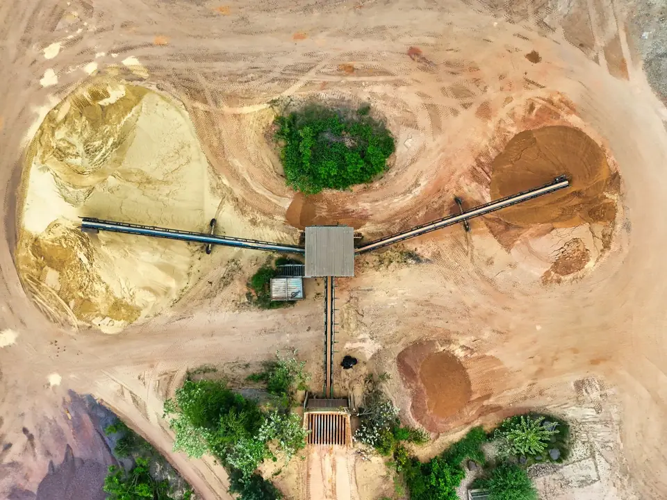
What is a drone volume survey
A volume calculation measures the volume of a body of soil, aggregate or material: a stockpile, a cutting, an embankment, a quarry pit or a landfill. With a drone, a complete model of the surface is obtained without climbing the stockpiles or stopping work.
Compared with the traditional method of profiles at set intervals, the drone measures the whole surface, with millions of points. The real shape of the stockpile, with its irregularities, is captured. And each flight leaves a dated model that serves as the base for the next one.
How it is calculated: surface comparison
The volume is calculated within a defined area, the perimeter of each stockpile or zone, by integrating the difference between two compatible surfaces: same reference, same grid and same processing. Simply subtracting a DTM from a DSM gives heights above a base, but it is not a universal recipe for volume calculation.
For a stockpile, the current surface (the DSM) is compared with a base surface agreed with the client: the original ground, the floor slab of the plant or a reference plane at a fixed elevation. The base chosen changes the result, so it is set before calculating and stated in the report.
For earthworks, two states are compared: the previous survey (the start of the works or the previous progress valuation) and the current one, or the current state and the design surface. Where the new surface is lower there is cut; where it is higher, fill. The result is broken down by zone, work front or work item.
Capture is done with drone photogrammetry, which produces very dense models on soil and aggregate surfaces, with GNSS RTK control points. When there is vegetation on the base ground, LiDAR is used: multiple returns help record the ground through gaps in the vegetation, and we check the coverage obtained.
Accuracy and formats
Typical accuracy of each surface is 2 to 5 cm, expressed as root mean square error (RMSE) on open ground or well-defined surfaces, in the project reference system (ETRS89 / UTM, with orthometric heights unless another reference is requested). It is checked against independent checkpoints that are not used in the adjustment. It depends on the sensor, the GSD, the ground control and the vegetation. The accuracy for each project is agreed in the proposal and documented in the control report.
The volume error depends on the accuracy of the two surfaces and on how the base is defined. That is why the report documents the area, the base chosen, the checkpoints and the error of each surface.
We deliver a PDF report with the volume by zone, the method and the checks; the zones and perimeters in DWG or SHP; the elevation difference map (cut and fill) in GeoTIFF; the tables in XLSX; and the compared surfaces with the orthophoto for each date. All viewable on our web GIS platform.
Stockpiles, quarries and earthworks
In quarries and aggregate plants, periodic flights keep the stockpile inventory by material type and track the progress of extraction against the working plan. In civil works, the monthly volume survey backs up the earthworks valuation with objective, repeatable data.
In landfills and fills, the volume used and the volume remaining are tracked. In urban developments and solar PV plants, comparing the original DTM with the designed platform anticipates the earthworks balance before work starts.
What volume calculations are used for
Common uses of drone volume surveys:
- Periodic stockpile inventory in quarries, aggregate plants and recycling plants.
- Earthworks valuation in civil works and urbanisation.
- Cut and fill balance of a design on the real DTM.
- Monitoring of fills, landfills and quarry restoration.
- Checking contractors' measurements and resolving discrepancies.
- Construction progress monitoring: change in volume moved between visits.
- Volume change and mass balance of glaciers between campaigns.
Questions about Volume calculations and stockpile volumes
How is a stockpile volume calculated with a drone?
The perimeter of the stockpile is defined and its current surface (DSM) is modelled with photogrammetry. It is compared with an agreed base surface: the original ground, the floor slab or a reference plane. The difference between the two surfaces, integrated within the perimeter, is the volume.
How accurate is a drone volume survey?
Each surface has a typical vertical RMSE of 2 to 5 cm, checked against independent checkpoints. The volume error depends on the accuracy of the two surfaces and on how the base is defined, and it is documented in the report.
Which surfaces are compared in a volume survey?
Two compatible surfaces: same reference, same grid and same processing. For a stockpile, the current surface against an agreed base. For earthworks, two surveys, or the current state against the design surface. Always within a defined area.
Can it be used to certify earthworks?
Yes. The surfaces of two surveys, or the current one and the design surface, are compared to obtain cut and fill by zone, with the method and the accuracy check documented. It is objective, repeatable data for the earthworks valuation.
Does the quarry or the site have to stop for the survey?
No. The flight is carried out without accessing the stockpiles or interrupting machinery. Its duration depends on the area and is set in the flight plan. Processing is done in the office.
Tell us where the project is and what you need to solve
You can send us the site boundary, a plan or the specification. We will reply within one or two working days to review the scope and confirm when you can expect the proposal.