GeoTIFF · ECW · GSD 2-5 cm
Drone orthophotos
An orthophoto is an aerial image corrected geometrically so that it has a uniform scale and real coordinates, which means it can be measured like a map. fita produces it with drone photogrammetry and GNSS RTK control, with a pixel size (GSD) of a few centimetres.
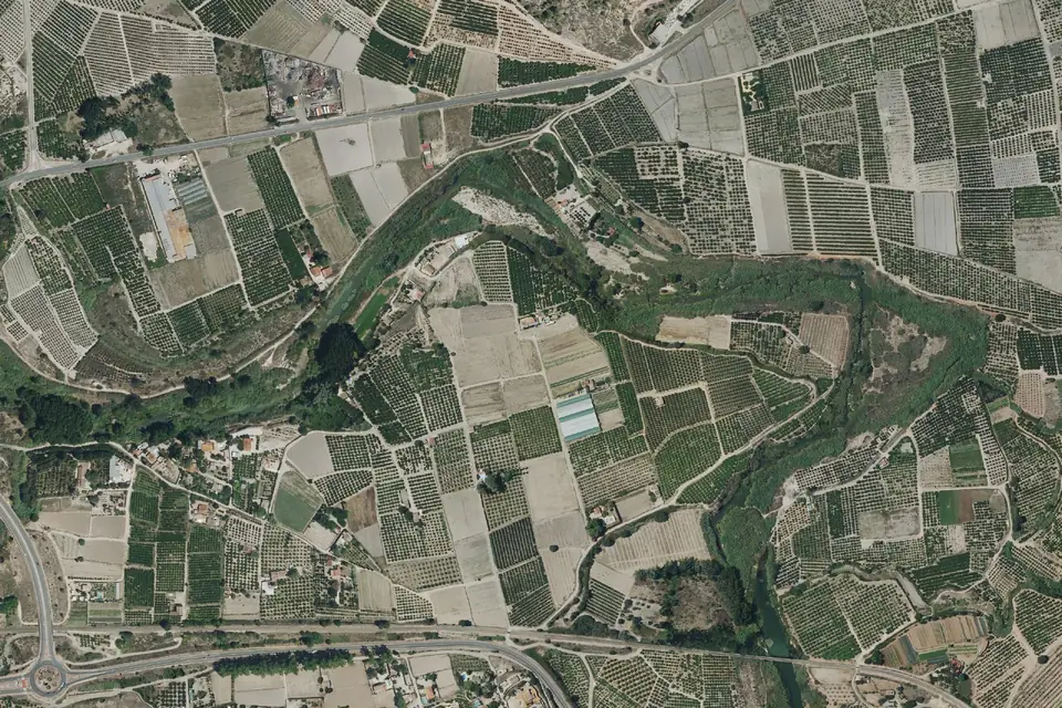
What an orthophoto is and what an orthomosaic is
In an orthophoto each pixel sits in its true position in a coordinate system, so distances, areas and angles can be measured directly on it. When it is built from hundreds or thousands of drone photographs, the result is called an orthomosaic.
The source photographs are georeferenced with the position of the drone at the moment each one was taken. Photogrammetric processing removes camera tilt and relief displacement, and projects the image onto the terrain model. The result is a continuous image, with no visible seams and with coordinates in ETRS89 UTM, the official reference system in Spain.
Orthophoto vs aerial photo: the difference
An aerial photo is a perspective view: objects away from the centre lean outwards, the scale changes with the relief and it cannot be measured reliably. An orthophoto corrects those effects. On an aerial photo you look; on an orthophoto you measure.
The difference matters as soon as the cadastre, an alignment or a setting-out has to be overlaid. On an uncorrected photo, a parcel can be shifted by several metres. The full explanation, with the geometry of perspective and relief displacement, is in the article what is an orthophoto and how it differs from an aerial photo.
How a drone orthophoto is produced
The flight is planned with high overlap between photographs, usually above 70% forward and 60% side overlap, at a height that sets the pixel size (GSD). Before the flight, ground control points (GCPs) are measured with GNSS RTK. These points tie the model to real coordinates and allow the accuracy to be checked at the end.
The metric RGB camera on the drone captures the images with their position and orientation. The photogrammetry software computes the geometry of all the photos, generates the terrain model and projects each image onto it. This produces the orthomosaic, which is reviewed, colour balanced and clipped to the project area.
For a true orthophoto (true ortho), in which buildings do not lean, the image is projected onto the digital surface model (DSM) instead of the digital terrain model (DTM).
Orthophoto resolution, accuracy and delivery formats
The usual GSD for this type of work is between 2 and 5 cm per pixel, depending on flight height and camera. It is the image resolution, not its accuracy.
Typical horizontal accuracy is 2 to 5 cm, expressed as root mean square error (RMSE) on open ground or well-defined surfaces, in the project reference system (ETRS89 / UTM). It is checked against independent checkpoints that are not used in the adjustment. It depends on the sensor, the GSD, the ground control and the vegetation. The accuracy for each project is agreed in the proposal and documented in the control report.
What fita delivers with an orthophoto
The exact content is set in the proposal. Usually:
- The orthomosaic as GeoTIFF with embedded georeferencing, as ECW for large files or as JPG with a world file.
- The true orthophoto, when the job requires it, projected onto the DSM.
- The orthophoto as tiles on our web GIS platform, to view without software.
- The control report, with the independent checkpoints and the RMSE obtained.
What an orthophoto is used for, by sector
The orthophoto is the background on which the rest of the project is drawn. Some frequent uses in the Valencia region (Comunitat Valenciana), across Spain and in Europe:
- Renewable energy, industrial estates and urban planning: base mapping for solar PV plants, estates and developments.
- Civil works: construction progress monitoring, with one orthophoto per visit to compare progress.
- Agriculture: parcel areas for the CAP (EU Common Agricultural Policy) and SIGPAC (Spain's agricultural parcel system), tree counts.
- Asset inventory on industrial estates, roofs and roads.
- Recording the condition of a site before works begin.
- Boundary checks and overlay with the cadastre. If the work continues with the documentation for the Cadastre and Land Registry, it is handled by Clotoides, fita's sister surveying company.
National PNOA orthophoto or a drone orthophoto
The PNOA (Spain's National Aerial Orthophoto Programme), run by the IGN (National Geographic Institute of Spain), offers free orthophotos of the whole country, with a pixel of 25 cm over much of the territory and 50 cm in other areas, with an update cycle that is currently three years. It is an excellent reference at a general scale and for checking what an area looked like in earlier flights.
Design work needs more. A project-specific drone orthophoto has a GSD of 2 to 5 cm/px, shows the site as it is on the flight date and is tied to control points measured in the field. It is the one that allows reliable measurement, setting-out and comparison. The guide PNOA LiDAR and IGN open data compares all the IGN products and explains when each is enough.
Questions about Drone orthophotos
What is an orthophoto?
It is an aerial image corrected so that it has a uniform scale and real coordinates. You can measure on it as you would on a map. When it is built from many drone photographs, it is called an orthomosaic.
What is the difference between an orthophoto and an aerial photo?
An aerial photo is a perspective view, distorted by camera tilt and relief. An orthophoto removes those distortions and is georeferenced. On the photo you observe; on the orthophoto you measure.
What is the difference between an orthophoto and an orthomosaic?
The orthophoto is the corrected image. The orthomosaic is an orthophoto built by joining many images, such as those a drone takes. In practice, the orthomosaic of a flight is the orthophoto that is delivered.
What resolution does a drone orthophoto have?
A GSD of 2 to 5 cm per pixel is typical, adjusted through flight height to suit the project. The national PNOA orthophoto has a 25 cm pixel over much of the territory. GSD is resolution, not accuracy.
What format is an orthophoto delivered in?
GeoTIFF, ECW or JPG with a world file, in ETRS89 UTM. It opens in QGIS, ArcGIS, AutoCAD Map or Civil 3D. We also publish it on our web GIS platform so that it can be viewed in a browser.
Is the PNOA orthophoto good enough for my project?
For a preliminary study or a presentation, yes. For design, setting-out or accurate area measurement, no: its resolution is tens of centimetres and it may be several years old. A drone orthophoto solves both issues.
How long does it take to produce an orthophoto?
It depends on the area, the GSD and the flight conditions. Processing and quality control are completed before delivery. A specific lead time is set in the proposal for each job.
Tell us where the project is and what you need to solve
You can send us the site boundary, a plan or the specification. We will reply within one or two working days to review the scope and confirm when you can expect the proposal.