ASC · GeoTIFF · XYZ · TIN
Digital terrain model (DTM)
A digital terrain model (DTM) is a grid of elevations that represents the bare ground, without vegetation or buildings. It is the starting dataset for contour lines, profiles, drainage and earthworks, and fita produces it with drone LiDAR or photogrammetry.
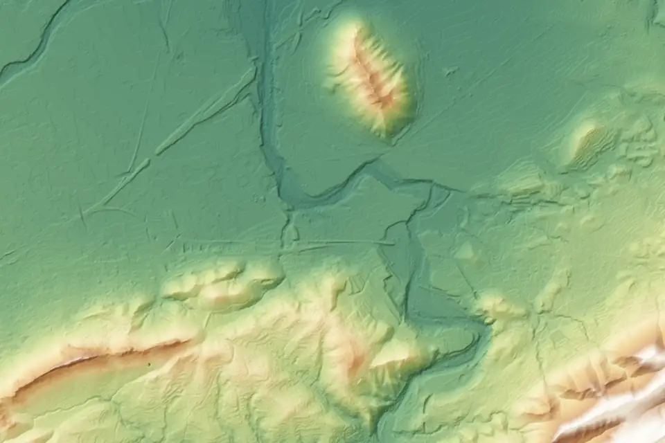
What a DTM is and how it is stored
A DTM is stored as a regular grid of cells, each with its elevation, or as a triangulated irregular network (TIN) that adapts to the relief. It contains no vegetation, buildings or any object standing on the ground: only the bare earth.
It is the base dataset of terrain engineering. Contour lines, slopes, aspect, alignment profiles, the drainage network and catchments all come from a DTM. It is also the reference for calculating cut and fill.
DTM, DSM and DEM: they are not the same
The DTM represents the ground. The DSM, or digital surface model, includes everything on top of it: buildings, trees, stockpiles. DEM, digital elevation model, is the general term used by the IGN (National Geographic Institute of Spain) and covers both. Both come from the same flight, and their difference gives the height of what stands on the ground.
To design on the ground, draw contour lines or calculate catchments, the DTM is used. For shading, building heights or the current surface of a stockpile, the digital surface model (DSM). The full comparison, with examples, is in the article DTM vs DSM: differences and when to use each.
How a DTM is produced with a drone
With LiDAR, the sensor emits laser pulses and records several returns per pulse. Multiple returns help record the ground through gaps in the vegetation, under trees or scrub. The point cloud is classified into ground and non-ground, and the DTM is interpolated from the points classified as ground. We check the coverage obtained: under very dense vegetation, ground points can be sparse.
With photogrammetry, the metric RGB camera produces a dense point cloud that is filtered to remove buildings and vegetation. It works well on open ground, low crops and construction sites. In both cases, GNSS RTK and ground control points fix the coordinates and allow the accuracy to be checked.
The technique is chosen according to the vegetation cover: LiDAR if there are trees or dense scrub, photogrammetry if the ground is visible. We often combine both in the same flight.
DTM resolution, accuracy and formats
The resolution of a DTM is its grid spacing: the usual range is 10 to 50 cm, depending on the area and the use. Resolution is not accuracy: a fine grid with poor accuracy is still wrong.
Typical vertical accuracy of a drone DTM is 2 to 5 cm, expressed as root mean square error (RMSE) on open ground, in the project reference system (ETRS89 / UTM, with orthometric heights unless another reference is requested). It is checked against independent checkpoints, measured with GNSS RTK or a total station, that are not used in the adjustment. It depends on the sensor, the GSD, the ground control and the vegetation: under dense vegetation the error is larger. The accuracy for each project is agreed in the proposal and documented in the control report.
What fita delivers with a DTM
The exact content is set in the proposal, according to what the model will be used for. Usually:
- The DTM as a GeoTIFF or ASC raster, in ETRS89 / UTM.
- The TIN mesh and the XYZ point file of the ground.
- DWG or DXF with points and breaklines, for Civil 3D and similar software.
- The point cloud classified into ground and non-ground, when the flight is LiDAR and it is requested.
- The control report, with the independent checkpoints and the RMSE obtained.
- The DTM as a layer on our web GIS platform, to view in a browser.
What a DTM is used for, by sector
Almost every project mapping product starts from the DTM. The most common uses:
- Renewable energy: slope and aspect maps for siting solar PV plants and wind farms.
- Roads and railways: longitudinal profiles and cross-sections of an alignment, tracks and canals.
- Civil works and quarries: earthworks by surface comparison (the DTMs of two surveys, or the current ground against the design surface).
- Urban planning and industrial estates: contour lines and topographic plans for building and urbanisation.
- Hydrology: drainage network, catchments and flood studies.
- Imagery: true orthophoto and image rectification.
When the DTM goes with boundaries and the cadastre
If the DTM accompanies a boundary plan or the technical documentation for the Cadastre and Land Registry, that procedure is handled by Clotoides, fita's sister surveying company. The fita terrain model is the base; the cadastral and registry part is carried out by Clotoides.
IGN DTM or a project-specific drone DTM
The IGN publishes free terrain models based on PNOA LiDAR, the LiDAR coverage of Spain's National Aerial Orthophoto Programme (PNOA). They are downloaded from the Download Centre of the CNIG (Spain's National Centre for Geographic Information). The MDT05, with a 5 m grid, covers Spain and, depending on coverage, there are finer products such as the MDT02 or the PNOA LiDAR point clouds. They are very useful for preliminary studies, options, large-scale catchments or a first estimate of slopes.
For each site, it is worth comparing the date, resolution, accuracy and detail of the available data with what the project requires. IGN data is enough for a study of options, a catchment or general slopes. It is not enough if:
- The ground has changed since the flight date (earthworks, construction, felling, a flood).
- Features a few metres wide matter: embankments, ditches, terraces, walls.
- There is dense vegetation and you need to know how many ground points support the model.
- Work is in progress and campaigns have to be compared.
- The tender requires verified accuracy and a control report for the job itself.
What else to know before ordering
The guide PNOA LiDAR and IGN open data explains which products the IGN publishes, at what resolution, how to download them, under what licence and when you need your own flight. If the DTM is for a survey, the drone surveying page explains how we work.
Questions about Digital terrain model (DTM)
What is a DTM?
A digital terrain model is a grid of elevations representing the bare ground, without vegetation or structures. Contour lines, slopes, profiles and catchments are derived from it.
What is the difference between a DTM, a DSM and a DEM?
The DTM models only the ground. The DSM also includes buildings, trees and any object on the ground. DEM is the general term that covers both. Both are obtained from the same flight, and their difference gives the height of what sits on top.
When is the IGN DTM enough and when do I need my own?
It is enough for preliminary studies, options and catchments. You need your own if the ground has changed since the flight, if features a few metres wide matter, if there is dense vegetation, if work is in progress or if the tender requires verified accuracy.
What is the MDT05?
It is the IGN digital terrain model with a 5 m grid, generated from the ground points of PNOA LiDAR. Each 5 x 5 m cell has one elevation, which smooths out embankments, walls and ditches.
How accurate is a drone DTM?
On open ground, a typical vertical RMSE of 2 to 5 cm, checked against independent checkpoints. Under dense vegetation, it depends on the coverage of ground points, which we check. We document the accuracy in the control report, with points measured in the field.
Can a DTM be obtained under vegetation?
With LiDAR, multiple returns help record the ground through gaps in the vegetation. We classify the ground points and check the coverage obtained; under very dense vegetation they may be sparse and the model less reliable.
What format is the DTM delivered in?
ASC or GeoTIFF for GIS, XYZ, TIN, and DWG or DXF for CAD and Civil 3D. The reference system (ETRS89 UTM) and the height reference used, orthometric or ellipsoidal, are stated.
Services that produce it and sectors that use it
Tell us where the project is and what you need to solve
You can send us the site boundary, a plan or the specification. We will reply within one or two working days to review the scope and confirm when you can expect the proposal.