GeoTIFF · ASC · XYZ · LAS
Digital surface model (DSM)
A digital surface model (DSM) is a grid of elevations of the surface visible from the air: roofs, tree canopies, stockpiles and, where there is nothing, the ground itself. It is used for shading analysis, building heights and the current surface of stockpiles, and it comes from the same flight as the DTM.
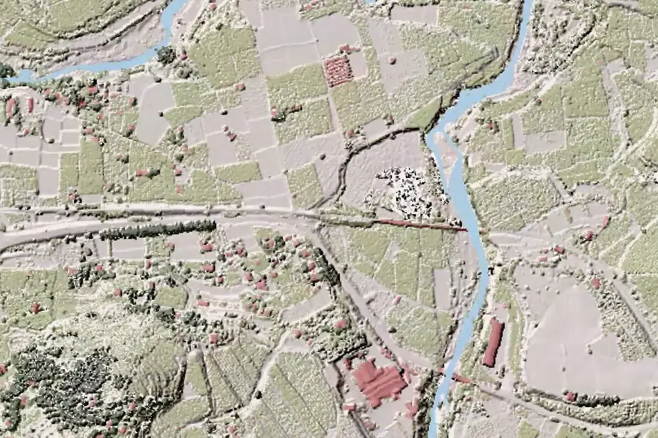
What is a digital surface model
A DSM is a grid of cells, each holding the elevation of the first thing a sensor meets when looking down from above. In an open field, it is the ground. In a town, it is the roofs. In a forest, it is the tree canopy.
The DSM is the complete model of the scene. It keeps buildings, warehouses, towers, trees, material stockpiles and machinery. That information is noise for some applications and exactly what is needed for others.
DSM, DTM and DEM: the difference
The digital terrain model (DTM) represents the bare ground; the DSM, the surface with everything on top of it. On ground without obstacles, the two coincide. Where there is a building, the DSM gives the elevation of the roof and the DTM that of the ground beneath it.
DEM (digital elevation model) is the general term for elevation models and covers both the DTM and the DSM, in line with the terminology of the IGN (National Geographic Institute of Spain). In many Spanish specifications, though, the surface model is called MDE, the Spanish for DEM. When a specification asks for a DEM, we confirm whether it means the terrain or the surface and state it in the report for the job.
The difference between the DSM and the digital terrain model (DTM) gives the height of what stands on the ground: buildings, vegetation or stockpiles. A volume also requires defining the area and choosing the base surface, as explained under volume calculations. The article DTM vs DSM: differences and when to use each develops the comparison with examples.
How a DSM is produced with a drone
With photogrammetry, the dense point cloud generated by the metric RGB camera directly describes the visible surface: the DSM is its interpolation into a grid. This is the most common route, with a GSD of 2 to 5 cm/px, which is the image resolution, not its accuracy.
With LiDAR, the first returns of each pulse are used, which correspond to the highest object the laser records. The result is more faithful at building edges and in vegetation. The DTM comes from the same flight: multiple returns help record the ground through gaps in the vegetation, and we classify the ground points and check the coverage obtained. GNSS RTK control points tie the model in both cases.
DSM accuracy, resolution and formats
Typical vertical accuracy is 2 to 5 cm, expressed as root mean square error (RMSE) on clear, well-defined surfaces (roofs, paving, ground), in the project reference system (ETRS89 / UTM, with orthometric heights unless another reference is requested). It is checked against independent checkpoints that are not used in the adjustment. It depends on the sensor, the GSD, the ground control and the vegetation. The accuracy for each project is agreed in the proposal and documented in the control report.
On vegetation, the elevation is that of the canopy, which changes with wind and season, and should be read as such. The resolution is the grid spacing, usually the same as for the DTM, 10 to 50 cm.
What fita delivers with a DSM
The exact content is set in the proposal. Usually:
- The DSM as a GeoTIFF or ASC raster, in ETRS89 / UTM.
- The XYZ point file and, on request, the classified LAS or LAZ point cloud it comes from.
- The DTM from the same flight, if the job needs both surfaces.
- The control report, with the independent checkpoints and the RMSE obtained.
- The DSM as a layer on our web GIS platform.
What a DSM is used for, by sector
The DSM is used when what matters is what stands on the ground:
- Renewable energy: shading analysis for solar PV plants, with the relief and the obstacles that cast shadows on the modules.
- Civil works and quarries: volume calculations for stockpiles and earthworks, where the DSM is the current surface compared with an agreed base surface within a defined area.
- Urban planning and industrial estates: building and warehouse heights, and viewshed analysis.
- High-voltage lines: vegetation height in the corridors.
- Imagery: true orthophoto, in which buildings are projected without leaning.
- Glaciers: change in the ice surface between surveys.
IGN DSM or a project-specific DSM
The IGN publishes a digital surface model, the model «with obstacles», derived from the first returns of PNOA LiDAR, with a 2 or 5 m grid step depending on the area. It is useful for seeing the approximate height of trees and buildings in a preliminary study.
It is not enough for detailed shading studies, for the surface of a stockpile or for vegetation next to a power line: its grid is metres wide, its date is that of the flight and the visible surface (canopies, works, stockpiles) changes over time. The guide PNOA LiDAR and IGN open data compares the IGN products and explains when you need your own flight.
Questions about Digital surface model (DSM)
What is a DSM?
A digital surface model is a grid with the elevation of the surface visible from the air: ground, roofs, tree canopies or stockpiles. It records everything that stands on the terrain.
What is the difference between a DTM and a DSM?
The DTM contains only the ground. The DSM also contains buildings, vegetation and any object on the ground. Their difference gives the height of what sits on top. A volume also requires defining the area and agreeing the base surface.
Is a DEM the same as a DSM?
Not always. DEM (digital elevation model) is the general term that covers both the DTM and the DSM. In many Spanish specifications, the surface model is called MDE, the Spanish for DEM. When we are asked for a DEM, we confirm which model is meant and state it in the report.
When do I need a DSM rather than a DTM?
When the project depends on what stands on the ground: shadows on panels, the surface of a stockpile, the height of a warehouse or of vegetation next to a power line. To design on the ground, the DTM is used.
Are the DTM and DSM obtained from the same flight?
Yes. With LiDAR, the first returns give the DSM and the DTM comes from the points classified as ground, whose coverage under vegetation we check. With photogrammetry, the dense cloud gives the DSM and filtering it gives the DTM. Ordering both does not mean flying twice.
Is the IGN surface model good enough?
For a preliminary study, yes: it gives an idea of the height of trees and buildings. For detailed shading, stockpiles or vegetation next to a power line, no, because its grid is metres wide and its date is that of the IGN flight.
Tell us where the project is and what you need to solve
You can send us the site boundary, a plan or the specification. We will reply within one or two working days to review the scope and confirm when you can expect the proposal.