Mapping ·
DTM vs DSM: differences and when to use each
DTM vs DSM explained with examples: what a digital terrain model is, what a digital surface model is, where DEM fits in and which one each project needs.
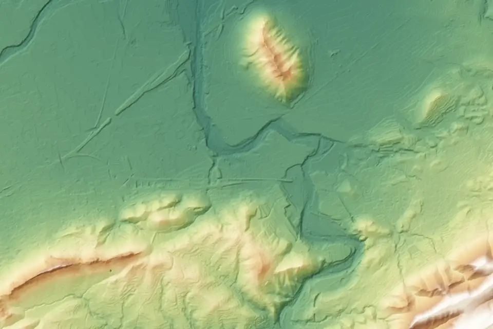
The DTM and the DSM are two digital elevation models that come from the same flight but describe different things. The DTM represents the bare earth; the DSM, the surface with everything on top of it: vegetation, buildings, stockpiles. Many Spanish specifications call the surface model MDE, the Spanish for DEM, and that causes much of the confusion. Confusing them leads to project errors, so it is worth being clear about the difference before ordering mapping.
What is a DTM (digital terrain model)?
A digital terrain model is a numerical representation of the height of the ground at every point in an area. It is stored as a regular grid (raster) in which each cell holds an elevation, or as a triangulated irregular network (TIN) based on measured points.
The key word is ground. A DTM does not include trees, buildings, vehicles, stockpiles or any other object resting on the terrain. If there is a pine wood on the site, the DTM passes beneath the treetops and represents the elevation of the soil.
That clean result is achieved in processing. From the point cloud (LiDAR or photogrammetric), the ground points are classified and the rest are discarded. The surface is then interpolated from the ground points. That is why the quality of a DTM depends above all on the quality of that classification.
What a DTM is used for
- Contour lines, longitudinal profiles and cross-sections.
- Calculating the slopes and aspect of a site.
- Drainage networks and catchments (watersheds) and flood risk studies.
- Site layout projects: solar, wind, urban development, road and rail alignments.
- The basis for earthworks, comparing the DTM with the design levels.
What is a DSM (digital surface model)?
This is where the terminology needs clarifying, because it causes almost all of the confusion.
We follow the terminology of Spain’s National Geographic Institute (IGN). DEM (digital elevation model) is the general term for height models and covers both the DTM (terrain) and the DSM (surface). The IGN groups its products as digital elevation models and, within them, distinguishes the two. In English usage, some sources also use DEM to mean the bare-earth model.
The digital surface model (DSM) is the model that includes vegetation, buildings and any object on the terrain. It is the first surface the sensor sees from above.
In many Spanish specifications, though, the surface model is called MDE, the Spanish for DEM. When a specification asks for a DEM, we confirm whether it means the bare earth or the surface with everything on it, and we state it in the report for the job.
What a DSM is used for
- Building and tree heights, from the difference with the DTM.
- Shading analysis for solar plants, where obstacles matter.
- 3D models of towns and industrial estates.
- Visibility and line-of-sight analysis.
- The current surface of stockpiles, which is compared with a base surface to calculate their volume.
DTM vs DSM: a direct comparison
| Aspect | DTM | DSM (surface) |
|---|---|---|
| What it represents | The bare earth | The first visible surface |
| Includes buildings and trees | No | Yes |
| Processing | Requires ground classification | Comes almost directly from the flight |
| Typical uses | Slopes, drainage, design | Heights, shading, 3D, stockpiles |
A concrete example. On an industrial estate, the DTM shows the levelled platform and the roads; a warehouse appears as a flat area at ground level. In the DSM, the same warehouse appears as a 12 m high block with its roof. Neither of them is wrong: they answer different questions.
The difference between the DSM and the DTM: heights above ground
Subtracting the DTM from the DSM gives a third model: the normalised height model (often called nDSM), which contains only what stands above the ground. It is a product in its own right.
- In agriculture, canopy height is used to estimate the vigour and biomass of tree crops.
- In urban planning, it gives the heights of existing buildings in a development area.
- On power lines, the height of the vegetation beneath the conductors is the figure that determines pruning.
Volume calculations: a surface comparison
The difference between a DSM and a DTM gives heights above a base, but it is not a universal recipe for volumes (see volume calculations). The volume is calculated within a defined area, the perimeter of each stockpile or zone, by integrating the difference between two compatible surfaces: same reference, same grid and same processing.
- On an aggregate stockpile, the current surface (DSM) is compared with an agreed base surface: the original ground, the floor slab or a reference plane.
- In earthworks, two states are compared, the previous survey and the current one, or the current state is compared with the design surface.
The error in the volume depends on the accuracy of both surfaces and on how the base is defined. We document it in the report for the job.
How a DTM and a DSM are produced with a drone
Both models come from the same flight. What changes is the processing.
- Flight with LiDAR, with a metric RGB camera or with both, supported by GNSS RTK and by ground control points (GCPs) measured in the field.
- Georeferenced point cloud. With LiDAR, millions of points with multiple returns; with photogrammetry, a dense cloud calculated from the images.
- DSM: interpolated from all the points, taking the highest one in each cell. It represents treetops, roofs and stockpiles.
- Ground classification: automatic algorithms separate terrain from vegetation and buildings; difficult areas (embankments, riverbanks, building edges) are reviewed by hand and the ground coverage obtained is checked.
- DTM: interpolated from the points classified as ground only.
- Quality control: comparison with independent checkpoints, measured with GNSS or a total station, and a control report.
LiDAR or photogrammetry for the DTM
The choice matters more for the DTM than for the DSM.
- With photogrammetry, the camera only sees the surface. On open ground (levelled platforms, short arable crops, quarries) the DTM is excellent. Under dense tree cover there are no ground points to classify: the DTM is interpolated blind and loses reliability.
- With LiDAR, multiple returns help record the ground through gaps in the vegetation. We classify the ground points and check the coverage obtained, which can be sparse under very dense vegetation. It is the right technique for woodland, watercourses with reeds, tree crops and any covered area.
For the DSM the opposite applies: photogrammetry, with a GSD (ground sampling distance) of 2 to 5 cm/px (the image resolution), gives a very detailed, textured surface; LiDAR gives a surface that is faithful at edges and in vegetation, but without colour, unless it is fused with the images.
DTM and DSM resolution and accuracy: what to ask for
Resolution is the cell size of the grid. A drone flight allows DTMs and DSMs with a cell size of 5 to 20 cm. For comparison, CNIG publishes the MDT05 for the whole of Spain and, depending on coverage, finer products such as the MDT02 or the PNOA-LiDAR point clouds. Asking for more resolution than the project needs only increases file size.
Resolution is not accuracy. Typical accuracy is 2 to 5 cm, expressed as root mean square error (RMSE) on open ground or well-defined surfaces, in the project reference system (ETRS89 / UTM, with orthometric heights unless another reference is requested). It is checked against independent checkpoints that are not used in the adjustment. It depends on the sensor, the GSD, the ground control and the vegetation. The accuracy for each project is agreed in the proposal and documented in the control report.
A practical rule for deciding:
- Site layout, drainage or earthworks project: DTM with accuracy control, 10 to 20 cm cell.
- Shading, heights or 3D: DSM, plus the DTM when heights above ground are needed.
- Stockpile volumes: the current DSM and an agreed base surface, within a defined area.
- Preliminary study without fieldwork: public IGN models, comparing their date, resolution, accuracy and detail with what the project requires.
Delivery formats
The DTM and the DSM are delivered in the formats the project software reads.
- Raster: GeoTIFF (with embedded georeferencing), ASCII Grid, XYZ.
- TIN mesh for CAD and construction software: LandXML, DWG.
- Derived products: contour lines in DWG or SHP, profiles in DWG or PDF, slope maps in GeoTIFF.
- Coordinate reference system: official ETRS89 coordinates (UTM, in the appropriate zone), orthometric heights, unless the client specifies otherwise.
When the client works with several tools, the usual approach is to deliver the model in GeoTIFF and the contours in DWG, and to publish everything on a web GIS platform so that anyone without specialist software can consult it.
Frequently asked questions
Is a DEM the same as a DSM?
Not always. Following the IGN terminology, DEM (digital elevation model) is the general term that covers both the DTM and the DSM. In many Spanish specifications, though, the surface model is called MDE, the Spanish for DEM. When we are asked for a DEM, we confirm which model is meant and state it in the report for the job.
Can a DTM be obtained from a DSM?
Only if the original point cloud is available to classify the ground. Buildings and trees can be filtered out of an existing surface grid with algorithms, but in areas of dense vegetation the result is an estimate, not a measurement. The correct approach is to generate both models from the point cloud.
What resolution does the IGN DTM have, and when is it not enough?
CNIG publishes the MDT05 for the whole of Spain and, depending on coverage, finer products: the MDT02 and the PNOA-LiDAR point clouds. They are generated from the LiDAR coverage of the PNOA (Spain’s National Aerial Orthophoto Programme), with several years between flights. For each site, it is worth comparing the date, resolution, accuracy and detail of the available data with what the project requires. Public data is useful for preliminary studies and options; a survey of our own provides the current date, the resolution and the control that detailed design requires.
What does fita need to quote for a DTM or a DSM?
The boundary of the area (a KML, an SHP or a plan), the intended use, the required resolution and accuracy, and the delivery format. With that, we define whether the flight is LiDAR, photogrammetric or combined, and the timeframe.
Our digital terrain model (DTM) and digital surface model (DSM) pages detail deliverables, formats and accuracy, and our drone LiDAR survey service explains how the terrain under vegetation is recorded.
Written by the fita team, drone mapping and surveying in Xàtiva (Valencia, Spain).